
ACTIVE ALERTS
FLASH FLOOD WATCH: BASTROP, LEE, AND LLANO COUNTIES UNTIL 7 A.M. SATURDAY
Though not necessarily continuous, a period of unsettled weather will prevail through the upcoming weekend. While strong to severe storms often accompany such events this time of year, the main focus will be flooding.
Thursday's cold front will result in a brief break in storm chances, but additional rounds of thunderstorms will be possible into the weekend. With unseasonably cool air at the surface, the severe threat appears to be low, but multiple rounds of rainfall may continue the flooding concerns.
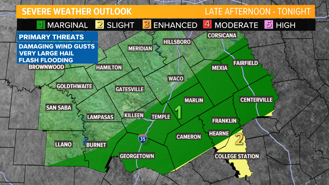
Scattered to numerous thunderstorms are expected Thursday through Saturday as well as Monday and Tuesday of next week. Localized flooding will be the main hazard, although a few storms could produce small hail.
Low-level moisture will finally return to the region Monday and Tuesday as the low-pressure system begins to weaken.
The moisture increase will bring more seasonable temperatures with lows in the 60s and highs in the lower 80s.
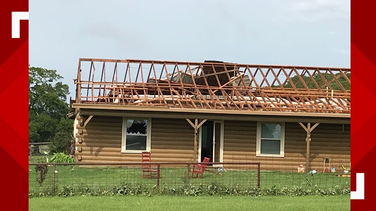
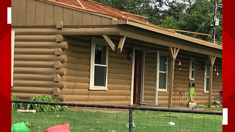
There was possible tornado damage in Elliott on Wednesday, as strong winds tore a home's roof apart.
Possible tornado damage in Elliott, Texas


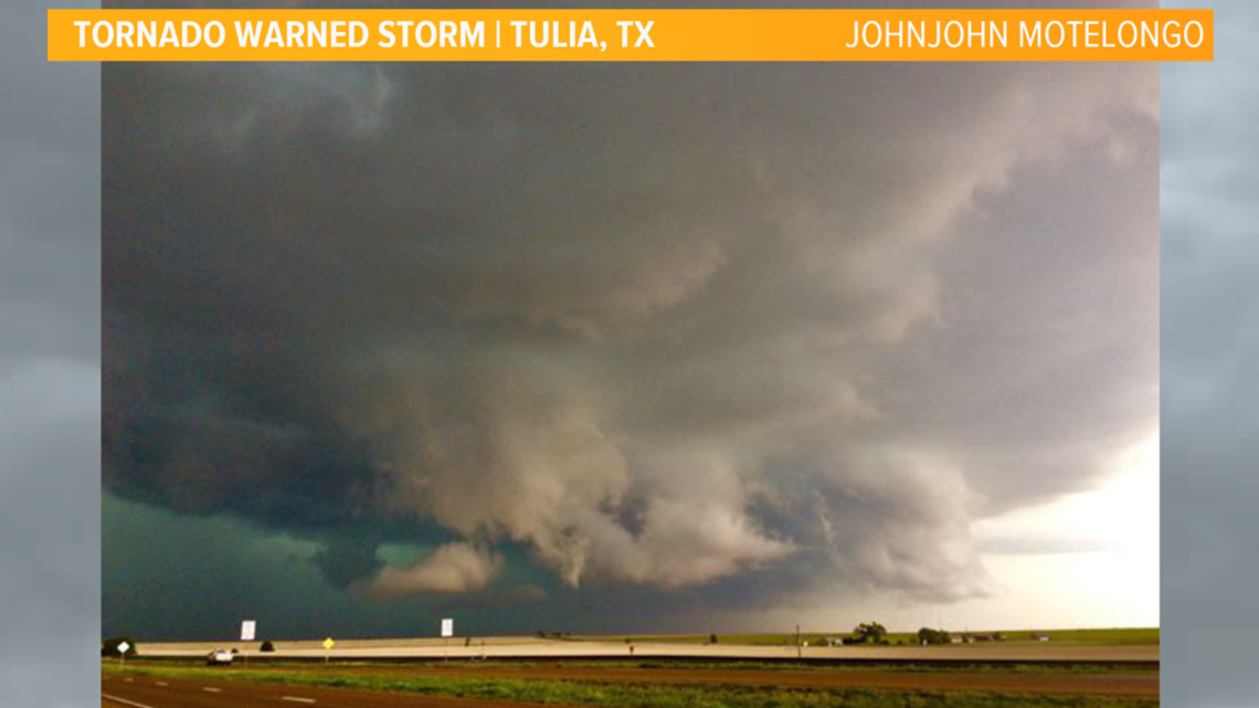
May is one of the stormiest months of the year for Texas and many severe thunderstorms packed a punch over the Texas Panhandle Wednesday.
Some took to Snapchat to share the view outside their windows.
A viewer captured an ominous view looking toward a tornado warned thunderstorm in Tulia before 6 p.m. Tuesday night.

►RADAR | Track rain, storms in Central Texas
This is a tricky forecast. Don’t let your guard down and stay alert. Keep the radar handy by downloading our KCEN6 app.
►KCEN Channel 6 News | Download the app
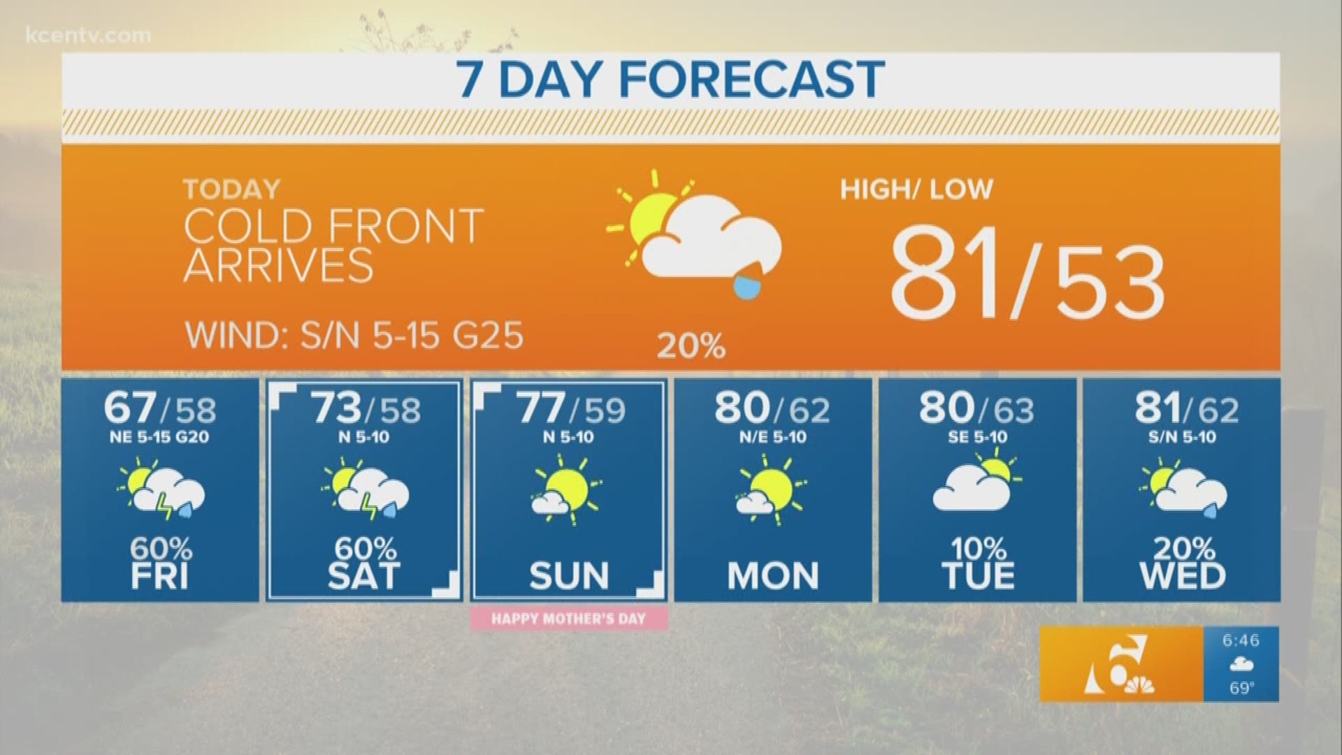
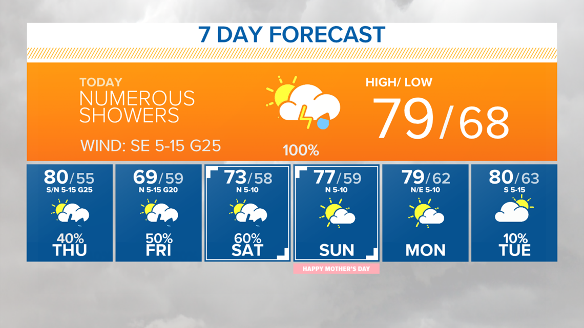
THURSDAY NIGHT: A 50% chance of showers and thunderstorms. Cloudy, with a low around 53. North wind around 15 mph, with gusts as high as 25 mph. New rainfall amounts of less than a tenth of an inch, except higher amounts possible in thunderstorms with a high near 78.
FRIDAY: Showers likely and possibly a thunderstorm before 1 p.m., then a chance of showers and thunderstorms after 1 p.m. Cloudy, with a high near 64. North wind 10 to 15 mph, with gusts as high as 20 mph. Chance of precipitation is 60%. New rainfall amounts between a quarter and half of an inch possible.
FRIDAY NIGHT: Showers likely and possibly a thunderstorm. Cloudy, with a low around 58. North wind 5 to 10 mph. Chance of precipitation is 70%.
SATURDAY: Showers likely and possibly a thunderstorm. Cloudy, with a high near 72. Wind: North northwest around 5 to 10 mph. Chance of precipitation is 60%.
SATURDAY NIGHT: A 20% chance of showers and thunderstorms. Mostly cloudy, with a low around 57.
SUNDAY: Mostly sunny, with a high near 75.
SUNDAY NIGHT: Partly cloudy, with a low around 58.
MONDAY: Mostly sunny, with a high near 77.
MONDAY NIGHT: A 40% chance of showers and thunderstorms. Mostly cloudy, with a low around 61.
TUESDAY: A 30% chance of showers and thunderstorms. Mostly cloudy, with a high near 62.
WEDNESDAY: A 40% chance of showers and thunderstorms. Mostly cloudy, with a high near 78.
YOUR 7 DAY FORECAST:

Unsettled weather will end Saturday afternoon then turn partly cloudy on Mother’s Day. Momma’s don’t have to worry about heavy rain on Sunday. It should be a nice day.
Stay up-to-date by downloading our free KCEN 6 mobile app. Radar, alerts, and video forecasts are available on the go.
►KCEN Channel 6 News | Download the app
►TRAFFIC CENTER | Keep a check on traffic
Chief Meteorologist Andy Anderson and Meteorologist Zac Scott will have the latest forecast updates at 5 p.m., 6 p.m., and 10 p.m. on KCEN Channel 6, and on Facebook.
Be sure to prepare your safe place in your home or at your job in case of a weather emergency.
When weather is happening, if it's safe, and ONLY if it's safe, post pictures on the KCEN News Facebook page and like the page for updates. Tag us in your tweets using @KCENNews using #KCENWeather #CenTXWX and #WeatherWarriors6
►Follow the weather team on Twitter
Stay weather aware with KCENTV.com: